Yoho National Park, British Columbia, Canada
Highlights along the route from Lake Louise, Alberta to -and within- Yoho National Park, British Columbia.
I’ve visited the area many times as a tour guide, as well as on my own.
From my experiences I offer suggestions for
• must sees – I put the highlights in an itinerary sample for a day of sightseeing
• active adventures
• a backcountry experience – for you who would like to stay a couple of days in the area.
Additional information on this page:
- Road Trip Map of the Highlights in and around Yoho National Park
- Services along this route
- Description of the Highlights in and around Yoho National Park
 Emerald Lake in Yoho National Park, BC
Road Trip Map Yoho National Park
Services along the route to, and within Yoho National Park
|
Gas Stations |
Accommodation Campgrounds Cell phone reach |
Highlights in and around Yoho National Park
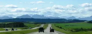
After your visit to Lake Louise, take Highway 1 West.
You enter Yoho National Park, British Columbia, 10-15 minutes later.
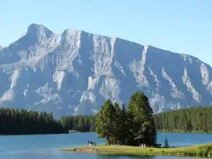
Continental Divide
When entering the park, you’re at the continental divide. Water floats east via the Bow River towards the Atlantic Ocean, and west via the Kicking Horse River and Columbia River into the Pacific Ocean.
A special viewpoint - the spiral tunnels – is an interesting stop located 18 km/11,2 mi. west of Lake Louise mall.
Spiral Tunnels

What’s a spiral tunnel? A solution to decrease a train rail grade.
By building a rail loop inside the mountain the original 4,5 % grade has been brought back to a gentler 2,25 %. This way, trains can safely get over and down, ‘The Big Hill’.
Two layers of the same train
If lucky, you might see a long enough train going in and coming out of the lower tunnel at the same time (the upper tunnels is on the other side of the highway and out of your view). As many trains are over 1,000 metres/1,094 yards long and the lower tunnel is close to 900 metres/984 yards, there is a good chance to see two layers of the same train above each other. What a spectacular view!
Train schedule
Although I’ve never been able to get a hold of a train schedule, I was lucky quite a few times around 1 pm and 5.30 pm.
If travelling from Lake Louise to Yoho National Park and back again, you will pass the Spiral Tunnel lookout twice. Any moving train on the other side of the highway, either just went through the tunnel or still has to go by it.
Construction of the Spiral Tunnels
When visiting the viewpoint you’ll see a scale model and a couple of
signs explaining the construction and history of the tunnels. I find it
very impressive.
- The construction of the tunnels took 2 years (1907-1909),
- about 1,000 men were laboured,
- 700,000 kg dynamite was used,
- the project took $ 1,500,000 to complete.
- In 1992, the tunnels were raised to allow double container transport.
Continue on Highway 1 West another 4 km/2,5 mi. and turn off at Yoho valley Road.
Yoho Valley Road and Takkakaw Falls
 Takkakaw Falls' main drop (254 m/833 ft)
This 17 km/10,5 mi. narrow windy road leads to my favourite waterfall; Canada’s third highest Takkakaw Falls, meaning magnificent in Cree (native language).
A steep switchback halfway up the road prevents tour buses and trailers travelling up.
The road is seasonally closed from early October until mid June.
Check Yoho Valley Road accessibility.
Takkakaw Falls
Takkakaw Falls is located at the end of Yoho Valley Road.
From the car parking, follow the trail to the right. It's a 10 min stroll to the viewpoint. If you don't mind getting wet, continue another 10 minutes to the base of the fall.
Not visible from the viewpoint is the upper part of Takkakaw Falls. The total combined height of the falls are 373 m/1224 ft.
The falls are fed by the Waputik Icefield
The Iceline Trail
The Iceline trail starts at the end of Yoho Valley Road.
This is a full day hike and one of my favourites.
It will take you about 7-8 hours to complete the 18-21 km loop.
 spectacular views onto Takkakaw Falls and the Waputik Icefield along the Iceline Trail
Continue route
Back on Hwy 1 West, take the first turn to the right, leading to Emerald
Lake. After a few hundred metres you’ll see the ‘Natural Bridge’
viewpoint.
Natural Bridge
A viewpoint along the Kicking
Horse River. White water carved an opening through solid rock; a
natural bridge arches the rumbling river.

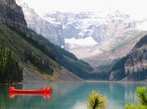
Emerald Lake
Park at the
end of the 8 km/5 mi. road at Emerald Lake, and walk around this
turquoise jewel. From the left lakeside you have a splendid view to
Mount Burgess.
This popular lake is great for canoeing, hiking or sightseeing, including a picnic on the lake shore.
Emerald Lake Trail
• The easy walk around the lake is 5 km/3,1 mi. in length.
• It takes about 1.5-2 hrs to complete.
• The left side of the lake is accessible to wheelchairs and strollers.
 Emerald Lake view halfway Emerald Lake Trail
Mount Burgess
In
1909 Charles Walcott discovered the ‘Burgess Shale’ fossils on this
2,599 metres/ 8,527 feet high mountain. It contained the fossilized
remains of more than 120 marine animal species dating back 515 million
years.
It turned out to be one of the most important fossil sites of
the world, and is designated a World Heritage Site in 1984. For almost
20 years, this mountain decorated the $20 bills.
Continue route
From
Emerald Lake Road, turn onto Hwy 1 West en follow 25 km/15,5 mi. to the
west entrance of Yoho National Park (no left turn is allowed when
travelling east to west on the highway).
Turn and come back for 3 km/1,9 mi., and turn right at the sign to Wapta Falls.
Follow the 2 km/1,2 mi. gravel road. Park here for a stroll to the falls.
Wapta Falls
A
2,3 km/1,4 mi. trail leads to a 150-metres/164 yards wide, and
30-metres/32,8 yards high, drop of the Kicking Horse River. It is the
biggest waterfall of this river.
Make sure to continue to the bottom
of the falls. The 60-metres/65,6 yards elevation loss (and gain on the
way back) is worth the effort.
Find out what happened to the red and grey dead trees in this area.

Day Itinerary Sample
Stick to the 'must sees' from 1st map layer.
Timing
9.00 am Leave Lake Louise village (at the mall)
9.15 - 9.30 am Viewpoint Spiral Tunnels
9.30 - 10.00 am Drive Yoho Valley Road
10.00 - 10.45 am Takkakaw Falls viewpoint
11.30 - 11.45 am Natural Bridge
12.00 Emerald Lake
12.15– 1.00 pm Picnic along the lakeshore
1.00 – 3.00 pm Walk around the lake or rent a canoe (call to reserve a canoe: 1-250-343-6000)
3.30 – 4.00 pm Spiral Tunnels 2nd chance
4.15 pm Return to Lake Louise
Are you more into an adventure vacation in Canada?
Select the 'Get Adventurous' layer in the map.
Go hike in Yoho National Park or get your adrenaline shot by rafting the roaring Kicking Horse River.
Hikes
You can take a Geo-walk or a guided hike up to the Burgess Shale
formation organized by
the GeoScience Foundation or by Parks Canada.
Day hike: The Iceline Trail
From
the parking lot at Takkakaw Falls, walk to the Whiskey Jack hostel.
From here the best hike ever starts; The Iceline Trail.
Kicking Horse River
Real thrill seekers have to experience the wild roaring Kicking Horse River (movie offered by Tourism Golden) by raft or kayak.
Several outfitters organize half and full day, guided rafting trips.
Only experienced kayakers should play with the class 2, 3, and 4 rapids.
Multiple days in and around Yoho National Park
If you have plenty of time to play with, make sure to visit Lake O’Hara, a true gem of the park.
Select 'multiple days' in the 3rd map layer.
Lake O’Hara
Lake
O’Hara offers breathtaking sub-alpine and alpine scenery. This is true
heaven for hikers and for those who would like to escape the
well-travelled routes.
Plan at least 3 months ahead for this unique getaway.
Shuttle bus
The only way to get to Lake
O’Hara is either by shuttle bus or by hiking in along an 11 km/6,8 mi.
dirt road. Reservations for the shuttle bus are required for going up
and can be made three calendar months in advance of your planned visit.
As
there is limited access into Lake O’Hara, seats are usually sold out
within half an hour after opening the reservation line. For going back
down you don’t need a reservation for the shuttle bus.
Check shuttle bus details.

How to Use the Road Trip Map
Use the map within this website or access each map in a separate full screen window (recommended).
For the latter, click on the 'view larger map' icon in the upper right corner.
- The first layer covers the must-sees in the region.
- The second points out the best activities when you’re more up to an adventure vacation in Canada.
- The third layer is for you who like to stay a couple of days off the beaten track in the backcountry.
Check or uncheck the box of each layer to hide or show the specific highlights that fit your style.
Icons
The icons in the map tell you the type of sight or activity– viewpoint (full or half circle)/ hike (hiking icon)/ mountain (mountain icon)/ rafting (water icon) or other (standard icon).
Zoom
Zoom in to enlarge a region. The zoom in/out icon is located in the left bottom.
Hold and drag
Hold and drag to move around on the map.
Sight info
Click on a specific sight to read a description of it.
Directions
Find directions from any location to a specific site, by clicking the arrow at the description box.
You might like these
Suggestions for Sightseeing Banff, Alberta, Canada
The best things to see and do in Banff. Including a map of Banff, highlights, and an itinerary sample for a day of sightseeing Banff
Lake Louise Alberta: Itinerary Sample and Road Trip Map
Suggestions for sightseeing and active adventures.Description of highlights, road trip map, itinerary sample for Lake Louise Alberta and surrounding area.
From Calgary to Banff: Highlights en Route
The most remarkable points of interest along the route from Calgary to Banff. Presents a road map, services en route, information, and itinerary sample


By Josette Prinsen, copyright ©2012 - 2026 Tourguide Canada
KvK 67595847 (CoC)
Last modified: Feb 22, 2026
Privacy policy | Disclaimer and Copyright | Site Map | Advertising Opportunities | Terms and Conditions