Free Campsites at Recreation sites in BC, Canada
Recreation sites allow you to escape to remote and spectacular Canadian destinations, free of crowds.
Free
campsites are offered at most of British Columbia’s recreation sites.
The majority of the locations are away from the highway, near rivers,
lakes and trails. Usually only locals know where to find them.
Enjoy the ultimate outdoor experience and travel Canada with a touch of adventure!
On this page:
Where to find free campsites in Canada
Accessibility of recreation sites
Maps with free campsites in British Columbia
 going wild
Available amenities
 gorgeous view from a recreation site in the Chilkoot
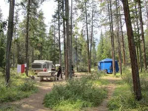
Recreation sites are basic and mostly without supervision.
Many sites allow free camping, sometimes referred to as dispersed camping.
They generally offer the following amenities:
- free spots for tenting or parking a vehicle (no hook ups)
- fire rings
- a boat launch
- gravel /pit toilets
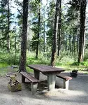
- a picnic table
Most free campsites and recreation sites DO NOT HAVE
- hook up for RV’s
- potable or running water
- paved road to access the site
DO NOT drink surface water without treatment as it can be infected with viruses, bacteria, parasites or heavy metals.
Site use etiquette
 this recreation site even has a cabin! Make sure to keep it clean and neat.
- Camping is allowed for as many as 14 consecutive days unless otherwise posted.
- When you leave a recreation site, make sure it is in the same condition as upon arrival.
- No commercial or group use is allowed unless you have written permission.
- Although most sites are free, some do charge a small users fee (max $ 10 - $ 15 per party per day).
Dispersed camping should leave minimal impact on the environment.
Read more about the camping etiquette for responsible free camping in Canada.
Where to find free campsites in Canada
Almost 1,300 recreation sites are available within British Columbia’s most spectacular pristine wilderness setting.
Many of them offer free campsites. For your convenience, I’ve put these locations together in 5 maps.
How to check the location of recreational sites while on the road without internet access!?
Find all BC recreation sites in the BC Backroad Mapbooks. All BC recreation sites are updated, listed and mapped in these books. Purchase a copy for less than the nightly price of a commercial campground, and take the Backroad Mapbook along on your road trip.
There is also a GPS version of the mapbooks. Please use one of below links to purchase. You will pay the same price as you would pay without my referral. However, by using these links I earn a small commission.. Thanks in advance!
Maps: recreation sites in British Columbia
The following 5 maps are organized from Eastern to Western British Columbia, based upon their geographic location.
1. South Eastern British Columbia – between Alberta border and longitude -117.999
2. South Central British Columbia – between longitude -118.000 and -120.199
3. Central British Columbia – between longitude – 120.200 and -121.499
4. South Western and Central British Columbia – between longitude -121.500 and -124.199
5. Western British Columbia – west of longitude -124.200
Please realize the recreational site information from the maps on www.tourguidecanada.com might not be up to date!
IMPORTANT
For the latest updated information check your selected sites at British Columbia Recreation Sites and Trails
Additionally, check for temporary site closures.
How to use the maps
Use the maps within this website or access each map in a separate full screen window.
For the latter, click the top right corner [ ] of each map.
Layers
The maps each contain 2 or 3 layers. Each layer covers a specific
geographic location, organized by its longitude within British
Columbia.
Check or un-check the box of each layer to hide or show the recreation sites within the geographic locations.
Icons
The icons in the map tell you if the site is accessible by –unpaved-
road (standard icon), boat (boat icon) or by trail (hiking icon).
Zoom
Zoom in to enlarge a region. The zoom in/out icon is located in the left bottom.
Hold and drag
Hold and drag to move around on the map.
Site info
Click on a specific site to see a description of it. Make sure to read
the information to find out if you can reach the destination with your
means of transportation. The description will mention if there are free
camping spots (often referred to as ‘sites’) offered.
Scroll
Scroll down within the description box to see information about
- accessibility,
- available structures, and the
- exact geographic location.
South Eastern BC – between Alberta border and Longitude -117.999
IMPORTANT
For the latest updated information check your selected sites at British Columbia Recreation Sites and Trails
Additionally, check for temporary site closures.
South Central BC – between longitude -118.000 and -120.199
IMPORTANT
For the latest updated information check your selected sites at British Columbia Recreation Sites and Trails
Check for temporary site closures.
Central BC - between longitude -120.200 and -121.499
IMPORTANT
For the latest updated information check your selected sites at British Columbia Recreation Sites and Trails
Check for temporary site closures.
South Western and Central BC – between longitude -121.500 and -124.199
IMPORTANT
For the latest updated information check your selected sites at British Columbia Recreation Sites and Trails
Check for temporary site closures.
Western BC – west of longitude -124.200
IMPORTANT
For the latest updated information check your selected sites at British Columbia Recreation Sites and Trails
Check for temporary site closures.
Accessibility of recreation sites
Many roads leading to recreation sites are unpaved forestry roads (gravel roads).
Some of the roads to more popular destinations receive some surface maintenance, such as grading and brushing. Other roads may be quite rough and not all vehicles are suitable for these types of roads.
If you drive a rental vehicle you should check your vehicle insurance policy regarding driving unpaved roads.
Not all hazards are signed. Be aware that road conditions can change at any time. Expect logging trucks, rough surfaces, potholes and cross-ditches on roads to remote locations.
Drive cautiously
Logging trucks use forest road. These trucks always have the right of way.
Download and print the guide for safe travel in Canada: forest roads
Campfires
Most recreation sites in BC offer fire rings. Before you make a campfire, check if there is a fire ban restriction in the area (check with British Columbia's Wildfire site).
You have a legal obligation to ensure campfires do not lead to wildfires.
Download, print, and read the Guide to Open Fires in Outdoor Stoves and Open Fires.
Let’s preserve free campsites for future generations.
For the Free an Independent Traveller
Check the road books I created for the free and independent traveller:
Road Book to travel from Vancouver to Calgary (one way)
Road Book to travel from Calgary to Vancouver (one way)
Road Book Vancouver to Victoria (round trip)
Road Book to Travel across Canada (one way)
Roadtrip Ontario and Quebec (round trip)
Free campsites in the USA
Are you interested in free camping in the USA?
Check out this article by Matt Suwak!
Matt covers the national forest camping rules, where you are allowed to camp in a national forest and how to find the best free camping sites near you.
You might like these
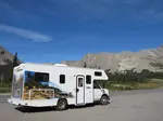
Find Free RV Camping for your Travel in Canada
Experience the ultimate outdoors while travelling and camping in Canada.Bring your expenses down and enjoy free RV camping
Camping in Canada. Different Types of Canadian Campgrounds.
Go camp during your travel in Canada! There is plenty of choice where to go camping in Canada. Where to find the several sorts of Canadian campgrounds.
Camping Etiquette: Reduce your Impact to the Natural Environment
DO’s and DONT’s when staying at a campground in Canada. Practise good camping manners; respect vegetation and wildlife.About general camping etiquette.


By Josette Prinsen, copyright ©2012 - 2026 Tourguide Canada
KvK 67595847 (CoC)
Last modified: Feb 22, 2026
Privacy policy | Disclaimer and Copyright | Site Map | Advertising Opportunities | Terms and Conditions